Kimberton – Phoenixville, Chester County [38-15-13]
The temperature was warm, but not to bad, and the skies were a deep blue with a few puffy white clouds.
It was another beautiful day in Chester County.
I started today’s adventure near the intersection of Route 100 and Route 113.
From there I took Pike Springs Road North (Rt. 113) towards Phoenixville, and was able to find Hares Hill Road on my left.
Turn on to Hares Hill Road, I immediately began to see signs that indicated that there was a bridge out in front of me.
My heart began to sink, thinking that this was going to be a wasted trip.
I ventured forth, continuing to see bridge close signs, and finally made it to Mill Lane.
Turning down Mill Lane, which is a small bumpy unpaved back-road, I reached the end , and was delighted to see a small little parking area.
Once I was parked, I noticed that the Closed Bridge signs had disappeared.
I gathered my gear, and headed down West Seven Stars Rd. towards the bridge, and was very happy to see that there was no construction visible anywhere!
At the entrance to the bridge, I stopped and began to assess the traffic situation.
I could see the bridge sign, just inside, and knew that I was going to have to do my dance with the oncoming cars and trucks.

With some quick timing, I was able to capture some hand-held bridge images, shot at ISO 1600.
On the sign, one can read, that the bridge had been destroyed by fire in 1986, but was rehabilitated a year later.
From there I moved back outside and to the base wall of the bridge and began to set up my tripod for my first exterior images of the entrance.
I knew this was going to take a long time, because the traffic seem to be increasing.
As I sat there, waiting for the cars, it was interesting to note how people responded to me and my camera.
Some folks, just wanted to make sure they didn’t hit you and continued along very quickly. Others would smile and wave and occasionally you would get a beep of the horn as a sign of encouragement.
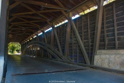
With the way the sun was hitting the bridge, I decided to walk through, and shoot back for my long interior capture, but in doing so, I had to set up my camera just at the edge of the traffic lane.
During my captures, I played a policeman with the ongoing traffic.
This was by far the most time-consuming image and nerve-racking of the day so far.

I got my captures and begin to look for my next shot.
Seeing that there were no easy ways to get under the bridge from the school side, I crossed back over, and down the opposite side I had shot from earlier.
This was nice because there was a little grass area where I could easily set up my low angle view of the bridge.
From here I moved upstream and look for an easy entrance into the water.
I found a spot, and started in, finally finding a spot on the far side of the Creek.
This was going to be another timings shot.
As I was setting up, I noticed that the school was having the lawns cut and large red mower kept on moving in and out of the shot, all the long kicking up dust clouds.

From there, I moved back down the Creek, crossing over the middle again, and towards the underside of the bridge.
Climbing over some rocks and up into the concrete area of the undercarriage, I was able to see that the underside for the first time.
The bridge had a light tan paint which was going to help to illuminate the support structure, and there was a nice contrast between the tan iron beams and the dark wood of the bridge itself, but I had to wait as red lawnmower continued to move back and forth off to the right.

From the middle of the undercarriage I continued to my right and up the side of the bridge.
As I scrambled up, I looked back and saw this long low view of the bridge.

This was my shot of the day.
But again I had to wait for Mr. Red lawnmower and the dust clouds…
Finally finished with the shot, I headed back to where I had started about an hour ago.
I started to head back to my car, got there, and decided to walk up the Creek a little bit more looking for another long view shot.
Heading back to the Creek, I found another easy entrance to the water and searched around for an appropriate view.
Finding one, I was able to capture this final image of the Kennedy covered bridge.

Tech Notes
During my processing of my images, especially HDR 07, I ran into a number of issues with ghosting and color aberrations.
Initially I posted to Flickr my first attempt of HDR 007, but after being too frustrated with what I was looking at, I re-released the image after spending some more time with it, and that is what is posted her. If you wish to see the original, it can be found on my Flickr PhotoStream.
Images Featured In
Destination Travel Magazine (June 2011) – Covered Bridges of Lancaster County
Destination Travel Magazine (May 2011) – Covered Bridges of Chester County
Destination Travel Magazine (April 2011) – Covered Bridges of Chester County
Reference Material
- Covered Bridge Table [Completed Project List]
– This list includes GPS coordinates, historical information and dimensions. - Google Map of Covered Bridges photographed by Andrew Seymour
View Covered Bridges – Photographed by Andrew Seymour in a larger map
Cross Links
- Covered Bridges {Love} by Snippets of Design